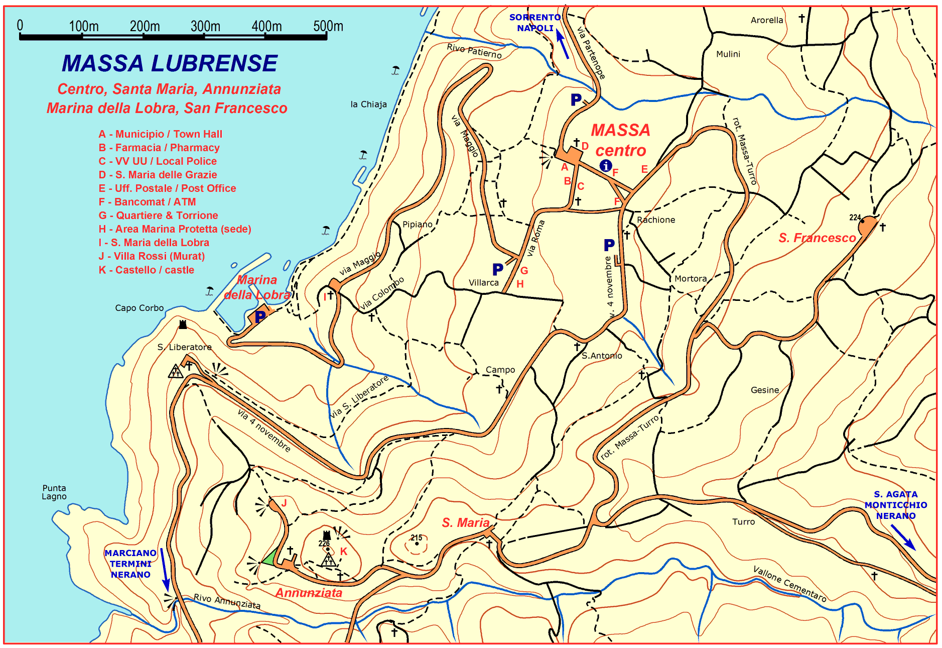
UA-46324036-2

Monday 27 April 2015

MORE NEWS FOR WALKERS IN THE SORRENTO PENINSULA

There is a new map of Massa Lubrense covering Massa centre, Santa Maria, Annunziata, Marina della Lobra and San Francesco. It can be downloaded from the following link:
 
Further to Giovanni Visetti's previous post regarding the App PDF-maps, the Path of the Gods is now also available for download. PDF-maps now have 5 of Giovanni’s maps: Capri, Path of the Gods, Massa and surroundings, Punta Campanella/San Costanzo and Sorrento.  

Via Li Schisani - apparently the Sorrento Town Council  has  at last decided to repair via Li Schisani. This path, although no longer much used by the locals, is of significant importance to hikers wanting to go from Sant’Agata to Sorrento or viceversa, being a convenient alternative to the very steep Circumpiso. Their first attempt at repair collapsed just a few weeks later and roughly ten years have passed meantime. Giovanni himself had suggested on more than one occasion that a temporary, simple and economic solution could have been to use chestnut-wood poles similar to those of the pergolas in our lemon groves to create a wooden catwalk over the affected area. Evidently this was too simple and economical, although the official reason was that it wouldn’t have met the safety regulations or been approved by the relative authorities.

Via Fontanella – according to the local press, work is about to commence on Via Fontanella following the landslide over a year ago. It should take roughly a month to complete. At the moment, walkers wishing to follow the red itinerary between Massa Lubrense and Sorrento (Pantano, Fontanella, Vigliano) have to deviate up to the church of Li Simoni.

Links to the relative blogs:

Wednesday 22 April 2015

IMPORTANT NEWS REGARDING GIOVANNI VISETTI'S MAPS & GPS

Some of Giovanni’s maps are now available on the website www.pdf-maps.com  and can be downloaded completely free of charge via the App PDF Maps.  This will enable any of you with GPS on your Apple iOS or Android not only to have off-line access to the maps, but also to locate your own position on the map.
This website, owned by the Canadian software company Avenza, offers many other useful functions and has thousands of different types of maps of varying scale and interest from all over the world. The App is free and can be downloaded to Androids or Apple iOS. It should also soon be available for Windows.
Once you have installed the App, you can then search for any maps of interest to you (Get maps). Avenza has both free maps and ones they charge for. You can filter the search to FREE only and once you have found what you are looking for, you will first see an anteprima including a description of the territory, and then you will be able to download the high-definition map of your choice.
For anyone needing maps of the trails of the Sorrento Peninsula, Amalfi Coast and Capri at present the following are available:  the map of the last segment of the peninsula (Punta Campanella, San Costanzo and Jeranto), the map of the island of Capri in its entirity and  the map of the historical centre of Sorrento, all complete with place names. These recently updated maps are already on line at www.giovis.com  but now by using the App PDF-MAPS, all you need is GPS on your phone/tablet and away you go!
Switch on the GPS, open the App and the map, and your position will appear on the map with no need of an internet connection, and all for free.
Giovanni now asks for everyone involved in the tourist industry, including the local authorities, to actively spread the news of this new service, to the benefit not only our visitors, but also of our residents.  
Hopefully this innovation, together with the proliferation of smart new maps complete with  QR codes that have recently appeared throughout the area will give rise to far fewer calls for help from lost excursionists. As I have said many a time, the Sorrento Peninsula, Amalfi Coast and Capri have so much to offer keen hikers of every level, so this is another step in the right direction.  
On Friday 24th April at 11.00 , Giovanni will be giving a short presentation of the pdf-maps App at the Pro Loco tourist office in Massa Lubrense. With a bit of luck the walking itinerary maps of Massa and Sorrento (Progetto Tolomeo) will also be available so that a short "test" walk  through the streets of Massa Lubrense using the App can  follow. 


WILD ORCHIDS AND THE SORRENTO PENINSULA


For anyone who appreciates the delicate intricacy of wild orchids,springtime in the Sorrento peninsula is the place to be.
Over the years,  I have gradually learnt when and where to find them, although they can sometimes  be seen simply flowering on the grass verges of the roads.
During my last few hikes, the routes admittedly chosen in the hope of being in the right place at the right time, I have not been disappointed finding a variety of ophrys, orchis, serapias and anacamptis.  


Wednesday 15 April 2015

Useful information for walkers in the Sorrento peninsula

Following a recent hike along most of the southern side of the Sorrento peninsula (Guardia to Punta Campanella), this is what Giovanni Visetti reports in his latest blog:   

Descent from the view point at Cafariello 
For several years now, the old trail along the ridge has been completely obstructed by dense vegetation. This is still the case, so Giovanni took the alternative path to the left of the ridge which descends in zigzags. This too was tricky due to the brambles.  Last year I tried both options, completely unsuccessfully. It is a shame because what could be a very pleasant alternative on the way to Crapolla or Monte di Monticchio  is no longer practicable. 


Cuparo 
For the past couple of years there has been a wooden signpost at the lower end of Via Corbo with the word "SENTIERO"  (path) written in red. A few metres further on, the path deviates, going down some rough steps to the lower terrace where the path continues. A wooden table discourages access to the upper, now cultivated terrace. 


The CAI trail between Guardia and the pinewood of Monte di Monticchio. 
Someone (probably not the CAI since the signs are red without the white stripe)  has re-marked the trail, at times a little too enthusiastically with an over-abundance of paint! This is of great help to anyone unfamiliar with this route and especially at the points where it is easy to go wrong. 


Link CAI 300 - Spina
Once past the valley to the west of Cuparo (this still needs to be crossed with the utmost caution), up to the right, well above the main path and painted onto the rock in big red letters is VIS (see photo). Being higher up, it can easily be missed. Out of curiosity, Giovanni decided to go and see where it led. The track is neither well-marked or particularly evident, but it you go in the right direction, it avoids you having to go first downhill and then back up again along the CAI path. 


New views on the way to Jeranto
The two rusty old pylons below the path have been taken down and will soon be removed along with the other 3 that had already collapsed. These have been an eyesore for years, so this is very welcome news and we can all thank Giovanni for getting the ball rolling with his original Blog on the subject


Via Calella Monticchio (via Gradoni)
This was paved a few years ago making the first part very easy walking. The next stretch is also clear of vegetation and simple to follow. However there has been a landslip just a few metres before the stream and a tree is now obstructing the path. The only way round is to clamber up the bank to the right and even so the channel is full of debris, very uneven and quite tricky to navigate. 


The ridge of Monte San Costanzo is spectacular at the moment, covered in pink asphodels. If you are able to go there over the next couple of weeks, you will not be disappointed. Quite a difference to five months ago in the aftermath of the fire!


Photos courtesy of Giovanni Visetti unless mentioned.

Thursday 9 April 2015

THE SORRENTO PENINSULA - A BOTANIST'S DELIGHT


Spring is by far my favourite season of the year mainly thanks to my love of flowers.
Living where I do,  I am well spoilt having a number of flower-lined trails virtually on my doorstep.
The other afternoon I took a short stroll along the slopes of Monte San Costanzo towards Campo Vetavole. I was not disappointed. 
The first wild orchids were in flower, and the hill side, covered in asphodels, had turned pink. Tiny blue speedwells, purple anemones, pink vetch, white daisies, spurges, wild rosemary and many many more all contributed to this early festival of flowers. And it is just April, there is so much more to come.
If you haven't been here already , the area of Massa Lubrense (Sorrento peninsula) is a botanist's delight from now until well into the summer. You don't have to be an expert hiker- there are several paths you can easily take. 
Go from Termini down towards Punta Campanella or from Termini up to Monte San Costanzo , enjoying not only the flowers but the views. Alternatively take the path from Nerano towards the Bay of Jeranto or walk up to Monte Vico Alvano from the Colli di San Pietro and on to the Sella di Arola. The choice is yours.


If you also appreciate good photography, check out the latest from Giovanni Visetti at the following links.


Thursday 2 April 2015

Making trails safe part 2 - Julian Tippett enters the debate.

I have received the following message from Julian Tippett, who many of you will know as the author of the excellent walking guide Landscapes of Sorrento, the Amalfi Coast and Capri . Many a British hiker (and not only) can be seen walking our trails clutching a copy of his book.
This is what he writes:
I was interested in two of your recent blogs:A Sorrento Amalfi Walking Festival - Why Not? and MakingTrails Safe
I don't see significant progress on either taking place in the foreseeable future for one simple reason: there is no authority in existence that can take responsibility for the work. Consider the fragmentation: Naples v. Salerno; the multitude of local councils; Comunità Montana; CAI. 
For work to be done consistently there needs to one organisation that both sees value in hiking (which means that money can be available to promote hiking) and has the power to get things done to a common standard (by setting up a hiking oversee body). All this is a million miles away. None of the current authorities meet the twin criteria.

None of the above should be taken as criticism of efforts that have taken place so far, all very laudable, and notably: CAI's way-marking and map producing activity; Giovanni Visetti's similar activity; the local councils in keeping the established paved footpaths in good repair, mapping by Giovanni Visetti and by Cart&Guide, my walking guide book. 


Hiking needs to be developed over a single area comprising: the Amalfi Coast, Sorrentine peninsula, and Capri. A hiking footpath authority needs to be established to act as the focus for activity on promoting hiking. This would have to be done in agreement with all local authorities, who would be the principal funding providers. Activity by the hiking authority would include: 


• setting up a register of paths to be included in the scheme, both paved and 'mountain'.

• devising a system for monitoring and recording their condition

• initiating work in liaison with the local councils and by employing contractors

• setting standards for signposting/ way-marking etc.

• obtaining funding

• additional activities e.g.: liaising with tourist information centres; ditto with walking holiday companies; ditto with walking guide book publishers; organising walking festivals.


The key to the above is a single common hiking footpath organisation. 
Julian concludes  posing the following open questions:
"Is this a valid aim? Is it feasible?"

Unfortunately having lived here for some time, and especially in the present economic climate, I for one personally very much doubt it.


UA-46324036-2