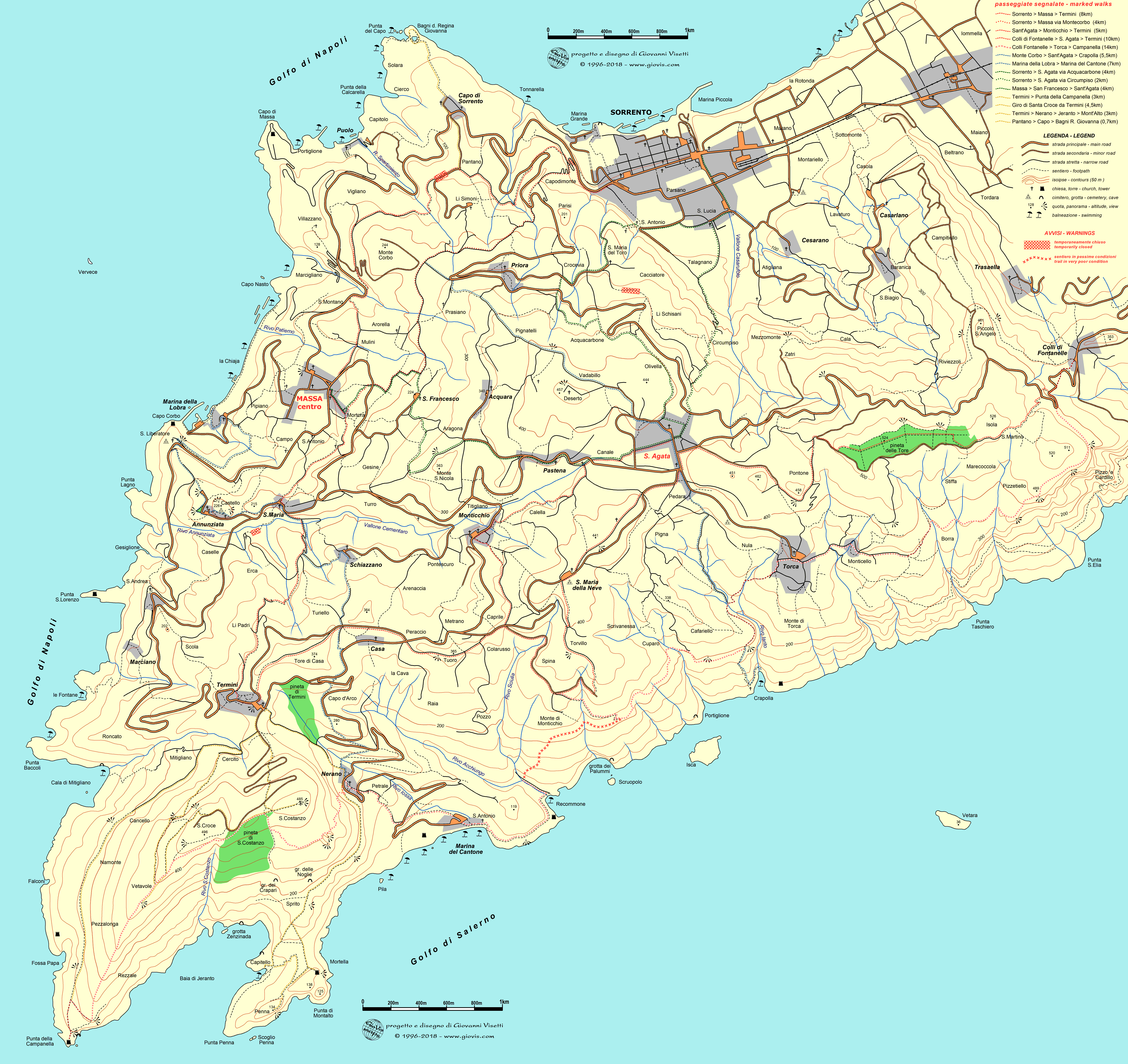
- religious buildings, of which there are many, positioned in the wrong location or incorrectly named. For example, San Liberatore cemetery has turned into the “Chiesa di Mitigliano” (35) . La church of Arorella has become the Cappella di S. Antonio (37) and Marcigliano has acquired the Chiesa di S.Maria della Purita' a Li Simoni (38). There are others, but I won’t bore you with the details.
- names of roads - incorrect spelling, such as Via del Moro (should be Via del Monte), incorrect location (Via Amerigo Vespucci which has ended up in the Camping Syrenuse), incorrect name (Via Nerano.... really?)
- out-sized toponyms crowding the map, badly positioned, incorrectly written and duplicated, creating not only confusion between the villages and hills/localities (which we locals know, but a tourist won't), but with some names not even attached to the actual place (take Nerano where the name has moved well away from the village, into the valley to the east).
- the icons - in the main centres there are so many that they hide points of interest/roads, and are often incorrectly positioned or misleading. The tourist office Proloco Due Golfi in Sant’Agata has moved 200 metres right down the road into Via Canale! Not to talk about the phantom public toilets situated in Sant’Agata and Torca or even the ones in Marina del Cantone, which do exist but are usually closed.
- the English –luckily, there is actually very little in English on this map, but what on earth is an “ancient washtub” (surely it should be washhouse?) or a “water’s house” ( water distributor)? I fail to understand, yet again, why they don’t just ask one of the many native English speakers to check things like this rather than trusting Google translate.
Sorrento Amalfi Walk With Us
Tales of life (and hiking) in the Sorrento Peninsula
Wednesday 15 March 2023
MASSA LUBRENSE - XII CANTO - NEW WALKING MAP
Sunday 25 September 2022
SORRENTO WALKS - A GREAT NEW WEBSITE FOR TREKKING ENTHUSIASTS!
A brand new website www.sorrentowalks.com is now online. The initiative, promoted by the local Sorrento Administration in collaboration with Penisola Verde and mentored by Giovanni Visetti, our expert local cartographer, is a positive step towards the promotion of trekking in the Sorrento Peninsula.
Produced in Italian, English and German, the site proposes a selection of itineraries, all starting in Sorrento that will take you to neighbouring localities mainly away from the main roads, following lanes, paths and trails historically used by the local population before today's roads were even built. Included are also three urban itineraries: itinerary 11 Walls & Gates of Sorrento, itinerary 22 Villages of the Sorrento Valley and itinerary 19 Sorrento - Sant'Agnello. Itinerary 22 is one of my favourites, so close to the centre, but a far cry from the usual tourist sites seen by the majority of visitors to Sorrento.
All of the walks are feasible for a reasonably fit person and in any case, thanks to the information provided for each one (elevation, distance and description), you can choose the ones most suited to you, maybe resorting to public transport for the return if you prefer.
Each itinerary, as well as a brief description of its actual route, also highlights points of interest along the way, which in turn are linked to short historical summaries.
The website describes the history of the Tolomeo Project, explains the waymarking and organisation of its network of itineraries, has a News section where you will be able to find useful information regarding programmed guided walks, maps etc., and a Contact tab. You can download the itineraries completely free and GPS coordinates are provided too.
We are now hoping that the local Authorities of Massa Lubrense, who are quick to use trekking as a selling point, will follow suit. Maybe for next summer? Who knows.
Monday 23 May 2022
HIKING IN MASSA LUBRENSE
Over the past few weeks there has been a lot of negative publicity about the state of the trails in Massa Lubrense and quite rightly so.
We all know that at this time of year vegetation grows thick and fast and nobody who hikes is afraid of a bit of grass and the odd bramble or two. However it is essential that the path beneath the vegetation is safe and not concealing traps: holes, chasms, landslips, loose stones and rocks, that could easily cause someone to trip, twist an ankle or worse. Just the other day a couple of British tourists made a formal complaint to the Mayor of Massa Lubrense about the state of one of the trails (Via Torvillo), calling it UNSAFE, which is precisely one of several that Giovanni Visetti (local hiking expert and cartographer) had flagged to the Council as in need of urgent maintenance. There are others too that are just accidents waiting to happen (see map below).Via Torvillo
On Sunday I took myself off on one of my favourite walks: the Giro di Santa Croce (or Vuallariello) that starts from the village of Termini, taking you up through woods to a trail running parallel to the better known path leading to Punta Campanella. This itinerary has become very popular not only for local walking groups but also for foreign hiking tours and figures in many of the more recent hiking guides. When the path was first cleared several years ago, there was a sign to point you in the right direction. That has gone, as has the ceramic tile that for a brief period of time marked its start. Now, if you manage to work out where it should be, you are faced by a big Private Property sign to your right and the entrance to a private house on your left and no path, since it has become totally overgrown. The ridiculous thing is that it is just the first 20 metres or so that are in this sorry state. After that it is clear and easy to navigate. It would take very little to restore the signage and clear the way.
Our local Administration has always professed a desire to promote trekking as one of the attractions of this area. On 11th April 22 they approved 2 "new" projects (one had been proposed by Giovanni Visetti back in 2020) to improve and update the network of trails in Massa Lubrense but since it is evident to all that they are incapable of maintaining the paths that we already have, there is a lot of scepticism as to if, how and when these projects will be completed.
We have read and listened to many words from them over the past months and years but quite honestly there has been little or no concrete evidence of them delivering the goods. In the meantime, both Sorrento and Vico Equense have completed projects in record time with new itineraries and way-marking and not only. Unfortunately Massa Lubrense is lagging far behind, stuck in a state of inertia, quick to present glorious new projects with a fanfare of trumpets, but then always ready with some excuse to justify the delays (just like the epic unfinished resurfacing of the roads, or the Massa Lubrense By-pass to nowhere, which are other tales to tell, but symptomatic of the general malaise of our local government).
Map showing in yellow points needing urgent intervention all flagged by Giovanni to the Local Authorities on multiple occasions. https://discettazionierranti.blogspot.com/2022/04/progetto-tolomeo-forse-se-ne-intravede.html?fbclid=IwAR3soN3Dse0fAyR-S_atJQiy4Qg4cC-_gLreoqqPo6jBTvwb_PLkkOPuzuo |
Tuesday 25 May 2021
TOLOMEO 2021 - HISTORICAL AND URBAN CIRCUIT - ITINERARY 11
ITINERARY 11 - THE WALLS AND GATES OF SORRENTO
A new itinerary of about 2,800 metres, with an extra 500 metres should you also wish to go down to Marina Grande. The cultural value of this urban route goes without saying, but it also has logistical merits. Its name already anticipates the fact that, as far as possible, it follows the boundaries of the city of Sorrento, still in evidence thanks to parts of the ancient walls that are still standing and to the seemingly unsurmountable cliffs and ravines.
Following this itinerary, you will also inevitably come to each of the five locations of the gates of Sorrento, which date back to various eras. Three of them are still standing and you will pass through them if you walk the entire circuit. Unfortunately there is no trace of the other two.
When Giovanni Visetti planned this itinerary it was with the intention of placing the starting points of the extra-urban itineraries in correspondence to the gates, because as in any part of the world, the roads beyond the walls originated from them.
One route starts from Porta di Parsano, 4 (ideally) from Porta di Massa (in actual fact from Piazza Veniero, due to its proximity and spaciousness, ) and the others from Piazza Tasso, where the castle and Porta del Piano stood with its bridge over the valley (see vintage image below, downloaded from the website www.ilmegliodisorrento.com).
Here is the list of streets and points of interest to be found if you follow the route clockwise from Piazza Tasso.11 Piazza Tasso, Vico S. Aniello, Via Pietà (Cathedral bell tower and entrance to the cathedral a few metres away), Via Padre Reginaldo Giuliani (Sedil Dominova), Via San Cesareo, Via Tasso, Via Sersale (Church of the Servi di Maria, Porta and Bastione di Parsano), Piazza Antiche Mura, Via degli Aranci (view of the walls), Largo Parsano Vecchio, Corso Italia, Piazza Veniero, Via Sopra le Mura, Via Marina Grande (Porta di Marina Grande), Piazza della Vittoria (belvedere of Prospietto), Via Vittorio Veneto (Villa Comunale, church and cloisters of San Francesco), Via San Francesco, Via Di Maio (AAST and belvedere), Porta di Marina Piccola, Piazza Sant’Antonino (Basilica di Sant’Antonino), Via Sant’Antonino, Piazza Tasso.
11a Via Marina Grande, as far as the church of Sant’Anna, passing through the Porta di Marina Grande
Giovanni Visetti has created this itinerary based on the city limits, the most well-known points of interest and the need to connect the starting points of the Tolomeo 2021 itineraries to a marked route. The choice of the historical, cultural, touristic and architectural elements will be up to the experts in the various sectors via the Sorrento Local Authorities and Penisola Verde who are coordinating the project.The above blog is a liberal translation of Giovanni's blog:
https://discettazionierranti.blogspot.com/2021/04/tolomeo-2021-5-circuito-storico.html
Tuesday 4 May 2021
TOLOMEO 2021 - THE OTHER 3 ITINERARIES FROM SORRENTO TO SANT'AGATA
TOLOMEO 2021 is a project developed by Giovanni Visetti, on behalf of Penisolaverde S.p.A. for the Municipality of Sorrento
The above text is liberally translated from Giovanni Visetti's Blog Discettazioni Erranti. Map and photos also courtesy of Giovanni Visetti.
Friday 16 April 2021
TOLOMEO 2021 - Itineraries through the Sorrentine woods
14 Sorrento - Monticchio (approx.5.1 km) via Priora and Acquara
Porta di Massa (Piazza Veniero), Via Fuoro, trav.Capo, Via Capo, Via Capodimonte, Trav. Capodimonte, Via Priora, Trav. Priora, Nastro Verde, Via Acquacarbone, Via Lamia, Via Deserto, Via Colli Acquara, Via San Vito, Via San Nicola, Trav. San Nicola, Trav Titigliano, Rot. Turro Pastena, Via S. Sossio, Via Savero Caputo, Piazza S. Pietro (Monticchio)
15 Sorrento - Sant'Agata (approx.4.5 km) via Acquacarbone
Porta di Massa (Piazza Veniero), Via Fuoro, trav.Capo, Via Capo, Via Capodimonte, Trav. Capodimonte, Via Priora, Trav. Priora, Nastro Verde, Via Acquacarbone,Via Olivella, Corso Sant'Agata, Largo Padre Ludovico da Casoria (Sant'Agata)
TOLOMEO 2021 is a project developed by Giovanni Visetti, on behalf of Penisolaverde S.p.A. for the Municipality of Sorrento
The above text is liberally translated from Giovanni Visetti's Blog Discettazioni Erranti. Map and photo of tile also courtesy of Giovanni Visetti.
Tuesday 6 April 2021
TOLOMEO 2021 - Itineraries between Sorrento and Massa Lubrense
Details of the itineraries
13 Sorrento – Massa centre (13a Punta del Capo, 13b Puolo) (4,5 km approx)
Porta di Massa (Piazza Veniero), via Fuoro, trav. Capo, via Capo, via Capodimonte, trav. Capodimonte, via Pantano, Nastro Verde, via Pantano, (start of 13a), via Fontanella, via Vigliano, via del Generale, via Partenope, via San Montano, via Mulini-Sponda, via Mulini, rot. Massa-Turro, viale Filangieri, largo Vescovado (Massa centre)
13a via Pantano, via Capo (x 13b for Puolo), calata Punta del Capo (400+800m)
13b via Capo, calata di Puolo, via Marina di Puolo, Puolo (1.100m dal Capo)
Friday 19 March 2021
SOMETHING TO LOOK FORWARD TO
Over the years the itineraries and maps were updated with new additions (such as the Giro di Santa Croce) and notice boards with large maps collocated at strategic points around the area, complete with QR codes for the technically minded. Digital versions of the maps were also made available by Giovanni on his web site, free to download: http://www.giovis.com/maps/Tolomeo2018.gif
Now for the news: Giovanni is in the process of revising and updating the Progetto Tolomeo in collaboration with the Municipalities of Sorrento and Massa Lubrense and with the coordination of Penisolaverde. New itineraries are being included and those falling within the territory of the Municipality of Sorrento have already been identified and traced.In addition to the two classic links to Massa Lubrense centre, there are half a dozen others going towards the villages up in the hills, including Zatri and Li Schisani for Sant'Agata sui due Golfi, both of which had fallen into disuse. There is also a completely new route through the chestnut groves of Lamia towards Acquara and Monticchio. Each itinerary is identified with different coloured number, painted trail markers, stickers on lamp poles and of course the ceramic tiles characteristic of the original project.
Two new circuits in the centre of Sorrento, are already accessible, identified by numbers 11 "The walls and gates of Sorrento" and 22 "The Villages of the Sorrento valley" going from Sorrento (Porta del Piano) to Cesarano, Cala, San Biagio, Baranica, Casarlano and Casola (locality "Sciuscelle"), returning to the centre of Sorrento. Clearly, each itinerary and each circuit can be walked in either direction.Now all we need is to be free to try them out!
(Photos courtesy of Camminate)